
Kunstareal - Sculpture in Public Space
Munich, Germany
October 27, 2006 - 16:15 UTC (17:15 local time)

Loading panorama viewer ...
Configuring ...
© 2006 Carl von Einem, All Rights Reserved.
Caption
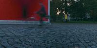
While walking through Munich on a nice evening I suddenly realised that I had just found a place that somehow met all the critera for the wwp events from 2006: the pavement shows borders to mark a bicycle path on the side walk. The place is part of a large area called Kunstareal where some of Munich's most important art museums and galleries can be found, with a sculpture garden right over the street in front of the yellow building (the Lenbachhaus). And just behind the oversized horn (a temporary installation by artist Benjamin Bergmann) there is the entrance to a very special museum which is somehow connected to transportation: it was built in a long room below the surface right over an underground station.Definitely a nice place to explore if you ever have the chance to visit Munich.
I want to thank the wwp organizers Don, Landis, Kat, Markus and Thomas. Thank you for all the work - and I look forward to several nice events in the coming year!
Location
Lat: 48° 8' 46.07" N
Long: 11° 33' 49.41" E
Elevation: 513 m (1683 ft)
Precision is: High. Pinpoints the exact spot.
Equipment
My usual setup for a short walk through the town:
- Voigtländer Bessa-L / 12 mm (rectilinear) ultra wide angle lens, Fuji Reala, Novoflex customised panoramic head and BasicBall mini tripod
- Nikon LS-4000 with Silverfast scanning software
- Photoshop, CubicConverter, VRPrep AppleScript
 Tap or click the zoom icon in the bottom right corner of the picture to switch between in-page and fullscreen view