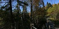

High Falls on the Pigeon River
Grand Portage State Park, Minnesota, USA
October 01, 2006 09:05 CST

Loading panorama viewer ...
Configuring ...
© 2006 Brandon Rowell, All Rights Reserved.
Caption
Minnesota's highest waterfall, the Pigeon River plummets 120 feet about a mile west of Lake Superior and creates a natural border between the USA & Canada.
Location
Lat: 48° 0' 15.76" N
Long: 90° 36' 49.27" W
Elevation: 688
Precision is: High. Pinpoints the exact spot.
Equipment
Canon EOS Digital Rebel (300D) DSLR, 8mm Fisheye Lens, ISO 100 @ f8, 1/250 sec., RAW
 Tap or click the zoom icon in the bottom right corner of the picture to switch between in-page and fullscreen view