

Loading panorama viewer ...
Configuring ...
© 2006 Bernhard Vogl,
Some Rights Reserved.

Caption
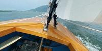
ENGLISH (hinunterblättern für die deutsche Übersetzung):Several people asked me how I accomplished to shoot this panorama while navigating the boat: First, I feel honored to be perceived as my father, a honorable person - even in his leisure shorts. Second, this panorama shows teamwork at its best: While he trimmed the boat, I shot the panorama.
At the time, I live several hours away from my parents. Chances became rare for my father and me to spend some time together. On this given day we took a chance to go out sailing - as we often did in my childhood.
In former times these hours on lake Traunsee weren't something extraordinary. Sometimes it was very boring waiting for a fresh breeze to come, sometimes we only used the boat as a vehicle to reach the next tavern on the lakeshore. And several trips we finished our sailing trip wet, but happy - because we mastered the severe "Viechtauer" storm (a wind blowing through the surrounding mountains like through a pipe).
You need some decades passing by to appreciate such moments...
DEUTSCH:
Einige Leute fragten mich wie ich dieses Panorama gemacht habe, während ich das Boot steuerte: Erstens fühle ich mich geehrt für meinen Vater gehalten zu werden - einer respektierten Person, auch wenn er gerade nur seine kurze Freizeithose trägt. Zweitens war das Panorama beste Teamarbeit: Er steuerte das Boot möglichst gerade über die Wellen, ich machte das Panorama.
Zur Zeit lebe ich einige Stunden entfernt von meinen Eltern. Die Gelegenheiten etwas gemeinsam zu unternehmen sind sehr rar geworden. An diesem Tag nutzten wir die Gelegenheit zu einer Segelrunde - etwas das wir in meiner Kindheit öfter gemacht haben.
Früher waren diese Stunden am Traunsee nichts Besonderes. Manchmal war es sehr langweiling auf eine frische Brise zu warten, manchmal nutzten wir das Boot nur als Fahrgelegenheit zum nächsten Gasthaus am Ufer. Und so manche Segelrunde beendeten wir nass, aber glücklich darüber, dem schweren "Viechtauer" Wind getrotzt zu haben (ein Wind welcher durch umliegenden Berge wie durch eine Düse verstärkt wird).
Es braucht einige Jahrzehnte um solche Momente richtig schätzen zu lernen...
Location
Lat: 47° 53' 54" N
Long: 13° 46' 50" E
Elevation: 420m
Precision is: Medium. Nearby, but not to the last decimal.
Equipment
Fuji S3, Sigma 8mm F4, Manfrotto Tripod, custom made panoheadSoftware: PTGui, Smartblend, Pano2QTVR
Panorama was made by creating two separate panoramas from one shot, one optimized for the boat, one for the coastal line. After merging the panoramas, the water area was painted to camouflage the non-matching areas.
 Tap or click the zoom icon in the bottom right corner of the picture to switch between in-page and fullscreen view