
Cruquius Steam Drainage Pumping Station
Cruquius, The Netherlands
September 11, 2006 - 12:48 pm (local time)

Loading panorama viewer ...
Configuring ...
© 2006 Arie P. de Ruiter, All Rights Reserved.
Caption
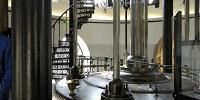
This is one of nine panoramas of Museum "De Cruquius" which I shot near the end of this Summer with the kind permission and assistance of Piet Beertema, webmaster of the Museum (for all panoramas, see http://www.ariederuiter.nl/cruquius-2006/index.html ). The Cruquius came into operation in 1849 as one of three steam pumping stations used to drain the Haarlemmermeer, now the home of a.o. Amsterdam Airport (Schiphol). The Cruquius stayed in service until 1932, was saved from demolition, and transformed into a museum.
The Cruquius steam engine is quite spectacular. It is the largest steam engine ever built, with a cylinder measuring more than 144 inch in diameter, and it was used to continuously drive eight cast-iron beams of 10 tons each.
The museum is well worth a visit for anyone interested in our technical and industrial heritage. The website of the Museum (http://www.museumdecruquius.nl/en/index.html ) contains a large amount of historical and technical information.
Equipment
Nikon D70 + Nikkor DX 10.5mm f/2.8D ED + Manfrotto 303SPH; Photoshop CS2 + PTGui 6.0.3 + Pano2QTVR 1.2.10
 Tap or click the zoom icon in the bottom right corner of the picture to switch between in-page and fullscreen view