
The Nuragic Well Temple of Santa Cristina
Paulilàtino (Oristano), Sardegna, Italy
July 14, 2006 - 14:30 CET

Loading panorama viewer ...
Configuring ...
© 2006 Alessandro Ugazio, All Rights Reserved.
Caption
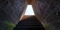
This is a well temple dating back to the late Bronze age (11th - 10th century b.C.).
In the nuragic era it was a sanctuary consecrated to the gods of the waters and of the underworld. Pilgrims must have gathered here for centuries from all of Sardinia, as witnessed by the little bronze figures found in this area. The site also includes the ruins of a nuraghe, a reunion hut, and many other buildings from different ages.
This is the best preserved, and one of the most beautiful, of about forty known nuragic well temples in Sardinia. Only some stairs have been restored, everything else is original.
Its structure is extremely rational and suggestive: the trapezoidal entrance opens to a staircase that descends to a tholos dome, similar in construction to the Treasure of Atreus in Mycenae, but much better designed and built, even though much smaller.
Looking up we can see an upside down staircase, that has been interpreted as a staircase designed for the gods of the underworld.
The dark basaltic stones are so perfectly cut that many archeologists have had doubts about attributing this work to the nuragic civility, but the finds at other similar temples have resolved those doubts. The temple is proof of the evolved architectural skills that nuragic people had, contemporarily to other Mediterranean peoples.
Recent studies and new hypothesis try to resolve some of the mysteries related to nuragic peoples and their disappearance. The most shocking hypothesis is the identification of Sardinia as Atlantis, the mythical continent submerged by the seas. Considering the different states of preservation of south and center Sardinia nuraghes, it seems that a giant tsunami had actually submerged a big part of the island at the end of the Bronze age, producing a brutal stop in naval traffics and sweeping away an entire population and culture, whose descendants spread around the whole Mediterranean diffusing their metals knowledge and technology.
(Thanks to Pat Swovelin for for american english corrections)
Additional links:
Italian journalist Sergio Frau's site (in italian): about the hypothesis of Sardinia as Atlantis, and the repositioning of the Pillars of Hercules between Sicily and Tunisia instead of the Strait of Gibraltar.
UNESCO announcement of the Atlantikà exposition in Paris, april 2005.
An interesting gallery of well temples and other nuragic buildings in Sardinia.
My web page showing other panoramas of the Santa Cristina site.
Equipment
Nikon D50, Nikkor DX Fisheye 10.5 mm f/2.8, Panosaurus head, Manfrotto tripod.Software: Nikon Capture NX, PTMac 4.1 by Kekus, CubicConverter 2.2.1, Adobe Photoshop CS2.
Il tempio a pozzo nuragico di Santa Cristina.
Questo è un tempio a pozzo risalente alla tarda Età del Bronzo (XI - X sec. a.C.).In epoca nuragica era un santuario dedicato al culto degli dei delle acque e degli inferi: pellegrini da ogni parte della Sardegna devono essere convenuti qui per secoli, come testimoniano i bronzetti rinvenuti nell'area. Il sito comprende anche i resti di un nuraghe, di una capanna delle riunioni, e di molti altri edifici di epoche diverse.
Il tempio è il meglio conservato di circa quaranta templi a pozzo conosciuti in Sardegna, nonché uno dei più belli. Solo alcuni gradini sono stati restaurati, il resto è tutto autentico.
La struttura è estremamente razionale e suggestiva: l'ingresso trapezoidale si apre su una scalinata che conduce ad una cupola a tholos simile al Tesoro di Atreo di Micene ma molto più raffinato nella costruzione, sebbene molto più piccolo.
Guardando in alto si nota una spettacolare scalinata capovolta, che qualcuno interpreta come percorribile dalle divinità degli inferi.
I conci di scuro basalto sono tagliati e assemblati a secco in un modo così perfetto da far dubitare i primi archeologi dell'attribuzione di quest'opera alla civiltà nuragica, ma il rinvenimento di altri templi simili ha fugato ogni dubbio. Questa perfezione testimonia le grandi capacità achitettoniche che i nuragici devono aver avuto, contemporaneamente ad altre civiltà mediterranee contemporanee.
Recenti studi e nuove ipotesi tentano di risolvere alcuni misteri relativi alla civiltà nuragica e alla sua scomparsa. La più sconvolgente è l'identificazione della Sardegna con Atlantide, il mitico continente sommerso dalle acque: considerando il diverso stato di conservazione dei nuraghi nel sud e nel centro della Sardegna, si direbbe che un gigantesco tsunami abbia effettivamente ricoperto gran parte dell'isola alla fine dell'Età del Bronzo, segnando una brusca interruzione dei traffici navali e probabilmente spazzando via un'intera civiltà, i cui superstiti si sarebbero sparpagliati per tutto il Mediterraneo, diffondendo la propria conoscenza e tecnologia dei metalli.
Behind the scene : how this panorama was made
Since the interesting points were higher or lower than horizon level, I chose to take two rows of shots every 60°, at +30° and -30°, plus a nadir shot.
I took bracketed shots: at f/16 and 400 ISO, the exposures were 1 sec (0 EV), 6 sec (+2 EV) and 1/2.5 sec (-2 EV).
I then decided to take some extra shots of the entrance to have a light blue sky to add: the one I used was 1/100 sec at f/16, 400 ISO.
 Tap or click the zoom icon in the bottom right corner of the picture to switch between in-page and fullscreen view