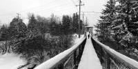

Swinging Bridge over the Bonnechere River
Renfrew, Ontario, Canada
December 20, 2005 at 1:30 PM (13:30 hrs)

Loading panorama viewer ...
Configuring ...
© 2005 Robert Agnel, All Rights Reserved.
Caption
Since 1895 the 'swinging bridge' located at the second chute on the Bonnechere River in the Town of Renfrew has allowed residents to access the north side of town.In the 1840s mills and factories were built at this location to take advantage of the abundant water power. Today there are two dams with hydro generators visible from the bridge. Panning right we see the upper power house (white brick building). The stone building on the hill is the McDougall Mill, now a museum displaying the history and contributions Renfrew has made to Canadian society.
With a couple of inches of freshly fallen snow on the bridge it didn't swing easily today, in fact it creaked and groaned when I walked across.
This panorama was produced on the Winter Solstice for the best of 2005 World Wide Panorama event.
For more panoramas and photos of Renfrew please visit Eady Realty at http://www.c21eady.com or Ottawa Panoramas at http://ottawapanoramas.com/QTVR%20valley/renfrewswingingb.html
Equipment
Nikon CP 950, E24 wide angle adapter, Kaidan KIWI head, QTVRS, Photoshop CS, QuickTime PRO,
 Tap or click the zoom icon in the bottom right corner of the picture to switch between in-page and fullscreen view