

Loading panorama viewer ...
Configuring ...
© 2005 Jim Watters,
Some Rights Reserved.

Caption
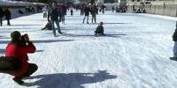
The Rideau Canal cuts through downtown Ottawa. When it freezes over in the winter, it is the world's largest skating rink. Winterlude is one of Ottawa's ways of making the most out of winter. At the center of the Winterlude activities the frozen Rideau Canal becomes a 7.8 kilometer skateway. For two weeks every February it is the center of many Winterlude activities. Other activities include ice caving and snow sculpture competitions, and outdoor performers.
This panorama was taken on a very cold Sunday afternoon on February 13. The weekends are always very busy.
More panoramas of the Rideau Canal in the winter and the summer.
More panoramas and photographs by Jim Watters at photocreations.ca.
Location
Lat: 45° 25' 23" N
Long: 76° 42' 27" W
Elevation: 80m
Precision is: High. Pinpoints the exact spot.
Equipment
Nikon Coolpix 995 with Fisheye(FC-E8) lens.6 around + 1 up + 2 down
Stitched with PanoramaTools using PTGui, Pano2QTVR & Photoshop
 Tap or click the zoom icon in the bottom right corner of the picture to switch between in-page and fullscreen view