
Canoe Rental at Moraine Lake
Banff National Park, Alberta, Canada
10:30 am, August 5, 2005

Loading panorama viewer ...
Configuring ...
© 2005 G. Donald Bain, All Rights Reserved.
Caption
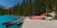
It was my fourth visit to Moraine Lake in ten years. Twice before it had been so rainy that I hadn't even taken my camera out. But this time it was perfect, bright sun and clear skies. It is always the color of the water that people exclaim about, and remember. If you haven't seen it before you may think the photos have been enhanced, but they haven't. Rock ground-up fine by the glaciers, known as "glacial flour", makes the water reflect a vivid aqua, even though it is really very clear. Striking even on cloudy days, in bright sun the color is truly amazing.
Moraine Lake in the Valley of Ten Peaks is a Canadian icon. For many years the view from the "Rockpile" (left end of the lake) appeared on the Canadian $20 bill. The peaks at the west end of the lake rise more than 4000 feet (1275 meters) above it.
Though perfect for photography, the day I took these photos was a bit windy for canoeing, so the Australian girls renting them had little to do but chat. Up the hill behind them is the comfortable Moraine Lake Lodge. Just a few miles away is Lake Louise, with its huge chateau-style hotel and mobs of tourists. A few miles further is the Trans-Canada Highway, thronged with traffic of the world's second largest country.
Banff National Park, Canada's oldest, is (together with Jasper National Park, adjacent to the north) a UNESCO World Heritage Site.
More of my VR panoramas of the Rocky Mountains:
The Canadian Rockies of Alberta, Canada
The Interior and Rocky Mountains of British Columbia, Canada
Glacier National Park and Western Montana, USA
The Canadian Rockies of Alberta, Canada
The Interior and Rocky Mountains of British Columbia, Canada
Glacier National Park and Western Montana, USA
Over 4000 VR panoramas of western North America at Don Bain's Virtual Guidebooks, many of them now available as fullscreens.
Equipment
Photographed with an Olympus E-1 dSLR, 14-54mm lens at 14mm (28mm equivalent), on a Kaidan QuickPan III with spherical adapter, Velbon tripod and Acratech ball head. Stitched with RealViz Stitcher 5, post-processing with Adobe Photoshop CS.
Behind the scene : how this panorama was made
My specialty is landscape photography, and for the most part I take cylindrical panoramas. They are more efficient and easier to produce than cubics (spherical), and usually all that is missing is more sky above and dirt below.But sometimes, particularly in the grand landscapes of the famous national parks of western North America, a cylinder isn't enough. So, about 5% of the time, I shoot multiple-row spherical panoramas.
This one consists of 24 shots around level, 7 shots up 45°, 7 shots down 45°, and a vertical zenith shot. The original stitched equirectangular image is 13,404 pixels wide by 6702 pixels high, a 202 mb file, which is of course reduced for web display.
 Tap or click the zoom icon in the bottom right corner of the picture to switch between in-page and fullscreen view