

Loading panorama viewer ...
Configuring ...
© 2004 Tom Pollak,
Some Rights Reserved.

Caption
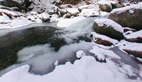
Brush Brook, a temporary sanctuary for my soul.Located in the Green Mountain National Forest, home to black bear, white tail deer, moose, to name just a few.
On the slopes of Camels Hump Mt, Brush Brook flows into the Huntington River, then into the Winooski River to pour into Lake Champlain, which runs into the Richelieu which flows into the Saint Lawrence then emptying into the North Atlantic.
a place not known for protection, but
a place to breath, in oneness with mother earth
a place to connect spirt - heart - mind
to feel balanced whole and complete
there, harm has no meaning.
For more New England Mt. panos at a related site
Teal City Media's Home Page
Location
Lat: 44° 12' 10" N
Long: 73° 55' 38" W
Elevation: 2000 ft
Precision is: High. Pinpoints the exact spot.
Equipment
Nikon coolpix 990 -- FC-E8
 Tap or click the zoom icon in the bottom right corner of the picture to switch between in-page and fullscreen view