

Loading panorama viewer ...
Configuring ...
© 2004 Robert C. Fisher, All Rights Reserved.
Caption
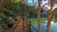
Sanctuary is a place we can rest, meditate, and rejuvenate the soul. In modern urban cities such as Los Angeles finding such a place can be daunting. The Lake Shrine of the Self-Realization Fellowship is a very peaceful park like area devoted to meditation and peace. A portion of Mahatma Gandhi's ashes are enshrined here in the Gandhi World Peace Memorial, the gateway to this memorial can be seen between the trees across the lake. The Golden Lotus Archway was unveiled at the dedication of the Lake Shrine in August 1950. Atop the archway is a giant golden lotus which in India is a symbol of divine unfoldment - the awakening of the soul to its infinite potential. More formal areas to worship include the Windmill Chapel, which is to the right of the opening frame and the new Temple located on the hill above the Golden Lotus Archway. A walking trail circles the lake and makes for a very peaceful stroll. This is one of the best kept secrets in Los Angeles, once found why would you tell anyone about it?
Equipment
Fuji S2 Pro Camera, Nikkor 10.5mm fisheye, Bogen 300 Panorama Head with custom multirow bracket.PTMac 2.1 v38, xBlend 2.1, Photoshop CS, CubicConverter 2.0.5, VRPrep
Behind the scene : how this panorama was made
It all started with the announcement of the WWP and the subject or theme of the panoramas. I was having trouble coming up with a good subject, or one that hadn't been too overdone. I tried to think of all the places I go when I need peace and meditation but none screamed . . . SHOOT ME. My girlfriend saved me as she does on a regular basis. She had gone to the Lake Shrine with a friend just a few weeks before so it was really fresh in her mind. Well as usual in Los Angeles, anytime I go out to shoot in public or semiprivate areas I expect trouble. I tried to scout the Shrine 2 times before I actually went there to shoot, once on a Monday I had off from work, Closed, and once on a day they should have been open, a Saturday, but they were closed again due to a private function. So the day I shot the Lake Shrine we took off not knowing if it would be open. We get to one parking area and that lot was to close in 15 minutes, rats! Well we went just 100 yards up the road to the main lot and it was open and the Shrine didn't close for a few hours. We jumped out and started around the lake, I found a spot I thought was a good place for a pano. No sooner had I shot 2 images that the authorities showed up, no professional (read Tripod) photography allowed without approval. So I told the gentleman what the WWP was about and made sure he understood that it was extremely non-commercial, he gets on the radio and it turns out to be no problem! Wow, not too many times does this happen in LA. I take this as a sign that this is the place for my panorama. So we continue around the lake and I shoot 8-10 panos from different locations, all while trying not to encroach on others private time. At one little grotto I had to wait for a gentleman to finnish his meditation before I entered the area and shot. As it turns out this is the most private place for meditation in the park.
This experience turned out well and I can't wait for the next Wide World Panorama to see what the theme will be and what we all can do with it. I will go back again in the future to shoot more panos of the Shrine and make a complete tour of the park. Still nothing can replace the experience of such a peaceful spot in an increasingly overcrowded city. I will post some of my other panoramas of the Shrine on my web page.
 Tap or click the zoom icon in the bottom right corner of the picture to switch between in-page and fullscreen view