
Ka'ena Point Natural Reserve
Western tip of O'ahu from Pu'u Pueo, Hawai'i, USA
Sunset, 19 December 2004

Loading panorama viewer ...
Configuring ...
© 2004 Pat Rooney, All Rights Reserved.
Caption
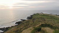
Since 1983 Ka'ena Point Natural Reserve has protected sea birds, including the wedge-tailed shearwater and the Laysan albatross, as well as sea life like monk seals. Native plants and insects thrive too, relatively removed from civilization. From either direction paved roads end about two or three miles away and populated areas are further yet, making this the most out of the way (but still accessible) area on an island of almost a million people. I saw a dozen people over the better part of the Sunday I took the panorama, most of them were fishing. A veritable sanctuary for everyone.I took the panorama from high up on the hill, Pu'u Pueo, in order to best see the 'sanctuary' part of the reserve – the sandy into green area up to the road bending around the point. This is where seabirds make ground nests. There are designated trails to walk and bike on.
According to Hawaiian legend Ka'ena is also a sanctuary of sorts for the departed. There is a large coral stone at the point called leina-a-ka'uhane meaning "spirit leap" from where deceased souls depart into the spiritual world. This is similar to other Polynesian cultures, the westernmost part of the island being closest to the setting sun.
Check here to see more pictures of the point and surroundings.
Check here for more panos by Pat.
Location
Lat: 21° 34' 21.99" N
Long: 159° 17' 17.73" W
Elevation: 150 meters, 500 feet
Precision is: Medium. Nearby, but not to the last decimal.
Pano Inspiration and Costal Reserve Information
In early December, with the new panorama theme of sanctuary in my head, I started hiking again with a trek to Ka'ena Point, a wildlife sanctuary, and met Bel, who I described the project to. I mentioned that I did a pano of the point before, but it wouldn't be very exciting, so he suggested we climb up the hill to the old military bunker for a better view. I came back a few weeks later and took this shot near sunset, two days before the solstice.From the sign at entrance gate:
KA'ENA POINT COSTAL RESERVE Ka'ena Point, the westernmost point on O'ahu, is the site of one of the last intact dune ecosystems in the main Hawaiian Islands. Dunes such as these were once found on most of the Hawaiian Islands. Unfortunately, these dunes and the natives species that live on them, have been almost entirely lost due to human impacts. Intact coasts are now only found at remote sites, and these last glimpses of the natural heritage of Hawai'i are precious. It was in recognition of this unique area that Ka'ena Point Natural Reserve was established in 1983. The plants and animals found here are protected by State and Federal Laws.
 Tap or click the zoom icon in the bottom right corner of the picture to switch between in-page and fullscreen view