
My Godparents' Farm
Sun Mountain Farm, Placerville, California, USA
3:00 PM 19 December 2004

Loading panorama viewer ...
Configuring ...
© 2004 Kat Kalamaras, All Rights Reserved.
Caption
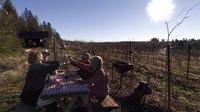
Sunday 19 DecemberThis may sound strange, but on that Sunday, my godparents' farm was a sanctuary for me. I had been trying to visit with them for some time and our paths were never really able to cross until our Solstice pano weekend. Landis and I were in high gear, Kahlua making and power knitting and gift buying and wrapping and baking...blah! It was a brilliant day to be away from home and with family.
We started our journey in a cold, foggy blanket from Petaluma. We didn't come out from under it until the foothills of El Dorado county 2 hours north and east of Petaluma. We emereged into the foothills with a deep blue, clear winter sky. From 44? to 66? Farenheit. I know, I'm a wimp.
We spent the whole afternoon with Joan and Stan Geel on their farm outside of Placerville. We had lunch outside were you see us. We started with one bottle of wine and ended with four. We conveniently moved a couple of bottles before my pano, so you wouldn't think we were lushes right at the outset.
It was a spectacular day! So we made a toast and worked on that fourth bottle of wine.
Location
Lat: 38° 44' 59.7" N
Long: 121° 44' 16" W
Elevation: 2818ft
Precision is: High. Pinpoints the exact spot.
Equipment
Hardware: Nikon D100, Nikkor 10.5mm Lens, Kaidan QuickPan III Spherical
Software: Kekus PanoTools Plug-ins, RealViz Stitcher, XBlend, Photoshop CS, CubicConverter, QT Player Pro, VRPrep
 Tap or click the zoom icon in the bottom right corner of the picture to switch between in-page and fullscreen view