

Loading panorama viewer ...
Configuring ...
© 2004 Jim Liesenfeld, All Rights Reserved.
Caption
Silver Creek Preserve is owned and managed by The Nature Conservancy of Idaho, a private non-profit organization whose mission is to preserve plants, animals, and natural communities that represent the diversity of life on Earth by protecting the lands and waters they need to survive. Silver Creek Preserve relies entirely on donations to meet its yearly management needs. Silver Creek Preserve protects one of the last intact examples of a high desert cold-spring ecosystem in the western U.S. Silver Creek’s spectacular habitat diversity, including shrub land, riparian forest, and wetlands, provides cover and food for over 150 species of birds. The creek is formed entirely by springs from an aquifer that originated along the Big Wood River to the north of the Preserve. Silver Creek’s water temperature remains relatively constant (50-60 degrees F). Much of the water is free of ice even during the coldest months making the preserve an oasis for wildlife throughout the year. The 25+ miles of Silver Creek that have been protected by the Nature Conservancy and with cooperation of local land owners, provides a profusion of plants, insects, and crustaceans. The cool clear waters host an unrivaled density of brown and rainbow trout, about 5000 trout per mile.
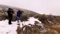
This morning's temperatures were around 10F (-15C) degrees with frost covering the surface and fog that persisted until late morning. Here Idaho Fish and Game Department volunteers, Jean Seymour and Kathleen Cameron brave the cold to participate in a monthly bird survey that has established Silver Creek as an important bird sanctuary.
Location
Lat: 43° 18' 51" N
Long: 115° 10' 9" W
Elevation: 4700
Precision is: High. Pinpoints the exact spot.
Equipment
Canon D60, Eos 17-40 @ 17mm f/9 1/90, Kaidan Quickpan III, PTMac-Xpoints-Xblend, CubicConverter, QTVRAS
 Tap or click the zoom icon in the bottom right corner of the picture to switch between in-page and fullscreen view