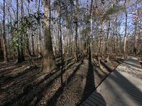

Congaree Swamp
Congaree Swamp National Monument. South Carolina, USA
12/21/04 11:00 AM EST

Loading panorama viewer ...
Configuring ...
© 2004 Don Barth, All Rights Reserved.
Caption
This is a major biological sanctuary and a spiritual one for me, located 20 miles outside of the capital of South Carolina, Columbia. It is "the largest contiguous tract of old-growth bottomland hardwood forest remaining in the United States. It is a designated International Biosphere Reserve."Better quality cylindrical panoramas of the swamp are linked from my home page.
Location
USA-Canada / USA-South Carolina
Lat: 33° 54' 15" N
Long: 81° 54' 11" W
Precision is: High. Pinpoints the exact spot.
Equipment
Coolpix 990 with EC-F9 fisheye. Kadian head. Panoweaver on Mac OS X to stitch.
 Tap or click the zoom icon in the bottom right corner of the picture to switch between in-page and fullscreen view