
A Misty Malvern Morning with Elgar
Malvern, Worcestershire, England, UK
December 22, 2007 - 06:08 UTC (06:08 Local Time)

Loading panorama viewer ...
Configuring ...
© 2007 Robert Bilsland, All Rights Reserved.
Caption
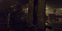
The Millennium Wrinkle in Time was the first panoramic Internet event I took part in. It had a shooting window the same as this event, 24 hours (any time during 1st January 2000). For this event I wanted to shoot the panorama exactly on the solstice and this presented me with the problem of it being 6:08am local time, well before sunrise.I decided not to travel too far at that time in the morning and was originally going to shoot an early morning view of Malvern Priory. Unfortunately like others on the day, I found out that after a certain time all of the outside lights are turned off. This forced a quick location re-think at the last minute.
After a quick 60 second walk I was here at my next location, standing next to Edward Elgar, looking down Church Street and watching the postal workers leaving in their vans delivering cards and presents. It was a dark and misty morning that I hope my panorama captures.
Location
Lat: 52° 6' 41.22" N
Long: 3° 20' 47.28" W
Elevation: 471 ft
Precision is: Unknown / Undeclared.
Equipment
Taken with a Nikon D70 and the standard 18mm-70mm lens (set at 18mm). Mounted on a home made multi-row bracket and a generic tripod. 3 rows (-45, 0, & +45 degrees) of 10 portrait photos taken 36 degrees apart and a single zenith photo. All photos shot in RAW mode. Panorama stitched using PTGUI / Panotools / Enblend and converted to a QTVR Cube using Pano2QTVR Pro.
 Tap or click the zoom icon in the bottom right corner of the picture to switch between in-page and fullscreen view