
Christmas at the Capitol
Olympia, Washington, USA
Friday, December 21, 2007, 14:43 Local Time, 22:43 UTC

Loading panorama viewer ...
Configuring ...
© 2007 Randy Kosek, All Rights Reserved.
Caption
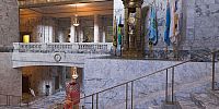
Taken in the Rotunda of the State Capitol in Olympia, Washington. When it was completed in 1928, the 278 foot dome was the fourth highest in the world.
Equipment
Canon EOS 5D Camera, Canon 15mm Fisheye Lens, 360Precision Adjuste Pano Head, Bogen Tripod with Self Leveling Head
 Tap or click the zoom icon in the bottom right corner of the picture to switch between in-page and fullscreen view