
Hawaiian Sugar
Ku'au, Maui, Hawai'i, USA
22 Dec 2007, 2:08 UTC; 21 Dec 2007, 16:08 local time

Loading panorama viewer ...
Configuring ...
© 2007 Edward Bigelow, All Rights Reserved.
Caption
Missionaries from the eastern USA brought Christianity to the sovereign Kingdom of Hawai'i in the early 1800's. A few missionary children grew to be oligarchs who owned the major commercial enterprises, including sugar production. In 1893 they overthrew the monarchy and deposed the queen with the aid of the US Marines. Hawai'i became a territory of the United States. In the 1950's members of US military forces stationed in Hawai'i were given voting rights and in 1959 Hawai'i became a state. On Nov 23, 1993, by Public Law 103-150, the US government made a formal Apology Resolution to the Hawaiian people for the overthrow 100 years earlier. Many issues remain unresolved, such as land use and water rights.
While sugar cultivation has gone from most of the Hawaiian islands, local resentment to the 1893 overthrow has not.
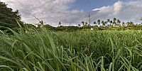
This sugar field will soon top with seed tassels, and in a few months be burned and mechanically harvested to produce over 200 tons of cane per hectare (c. 20 tons sugar.) Between competition, low market value of sugar, cost of fuel and pollution, it is not clear how long the fields can continue to be burned or cultivated. Some think biofuel production will reinvigorate the industry.
Location
Lat: 20° 55' 37.29" N
Long: 157° 23' 0.13" W
Elevation: 16m
Precision is: Medium. Nearby, but not to the last decimal.
Equipment
Nikon D40x, Peleng 8mm, NN2 with oblique bracket on elevated monopod (camera at >3m). ISO 200, 1/400th, f/8.
 Tap or click the zoom icon in the bottom right corner of the picture to switch between in-page and fullscreen view