
Ice Near Pier
Utkina Zavod', Saint-Petersburg, Russia
December 22, 2007 - 14:19 UTC (17:19 local time)

Loading panorama viewer ...
Configuring ...
© 2007 Andrew Varlamov, All Rights Reserved.
Caption
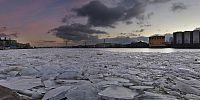
When You observe sattelite map of this place obtained from Google Maps, You can remark that map lies, because it shows vessel and krane arrounded by hills of crushed stone or sand. Oops, but Google still don't invent how to show us season-oriented sattelite maps - green in summer, yellow and red in autumn, white in winter.Today is winter, and pier is closed as waterways are covered by ice.
These pebbles on the pier remind me edict that Peter the Great issued after Saint-Petersburg was founded in 1703 : "Every cart arriving Petersburg is obliged to pay duty of 3 stones (cobblestones), every vessel - from 10 to 30 stones. Every citizen is obliged to give city 100 stones...".
Celebrating today Wrinkle's 10th anniversary I would like to wish : let these humble panoramas remain in our memory as starting point for current and future worldwide projects of panoramic photographers !
Interesting links about this place:
- Album of AQUARIUM "Fisherman Songs" (2003) contains song "Utkina Zavod' (Duck Cove)"
- Development project "Utkina Zavod'"
Location
Lat: 59° 52' 11.53" N
Long: 30° 28' 47.64" E
Elevation: 0
Precision is: High. Pinpoints the exact spot.
Equipment
Camera: Pentax *ist DSLens: Pentax SMC P-DA Fish-Eye 10-17mm F3.5-4.5 ED (IF)
Head: Manfrotto 303SPH
Tripod: Manfrotto 190XB
Software: Adobe Photoshop 7.0 CE, PTGui 7.3 by New House Internet Services B.V. (dated by October 2, 2007), MinGW version of PanoTools library 2.8.0 (dated by November 24, 2005) from Jim Watters' PanoTools site, Pano2QTVR version 1.5.2 pro flash by Thomas Rausher.
Caption in Russian - Лед у причала
Если посмотреть на сайте Google Maps спутниковую карту этой местности, можно заметить, что карта неверна, у пристани видны баржа и кран, окруженные кучами то ли щебенки, то ли песка. Увы, Google еще не придумал, как выдавать нам спутниковые карты-хамелеоны: зеленые летом, желтые и красные осенью, белые зимой.Сегодня зима, река подо льдом, и пристань закрыта.
Камни щебенки на пристани напоминают об указе Петра Первого, изданном после основания Санкт-Петербурга в 1703 году : "С каждой подводы, въезжающей в город, - по 3 камня, с каждого судна - от 10 до 30 камней. Каждый житель обязан доставить в город 100 камней...". Камни эти шли на мощение улиц.
Празднуя сегодня десятую годовщину Wrinkle, хочется пожелать, чтобы эти скромные панорамы остались в нашей памяти как отправная точка для нынешних и будущих всемирных проектов панорамных фотографов !
Интересные ссылки об этой местности:
- В альбоме АКВАРИУМа "Песни Рыбака" (2003) есть песня "Уткина Заводь (Краковяк)"
- Девелоперский проект "Уткина Заводь"
Behind the scene : how this panorama was made
Weather conditions were fine : light northern wind, clean sky without rain or snow. I shoot 8 (6+1+1) double exposed shots to catch both shadows (1/30sec, F/4, ISO 200) and sky (1/125sec, F/4, ISO 200). After that I went to new bridge looking for suitable location to shot panorama. Perhaps I will find enough time to stitch and publish this panorama at viewat.org.
 Tap or click the zoom icon in the bottom right corner of the picture to switch between in-page and fullscreen view